
Google Maps recently updated the name of Lake Ontario to Lake America for users located in the United States following an executive order signed by President Donald Trump.
What seemed like a straightforward update for American screens quickly confused the border in Canada. People in Ontario opened local government websites, school district pages, and business portals only to see Lake America displayed on their local interactive maps.
The unexpected appearance of Lake America on Canadian devices sparked widespread discussion, debate, and technical troubleshooting. The situation shows how deeply digital mapping algorithms shape our everyday view of geographic boundaries. It also highlights what happens when global technology companies attempt to navigate political disputes between neighboring nations.
Understanding how this change occurred requires looking at the technical mechanics of online maps, the political background behind the name change, and the quick response from Canadian officials and technology providers.
The Executive Order Behind the Name Change
The origin of this geographic dispute stems from a decision made by the United States government. President Donald Trump signed an executive order directing the U.S. Geographic Names Information System, known as GNIS, to formally rename Lake Ontario as Lake America. GNIS is the official federal database that maintains standard geographic name usage for the federal government of the United States.
Build Funnels, Email Lists & Sell Online With One Free Tool
Create funnels, send emails, and sell online using Systeme.io without paying for multiple tools.
Create Free AccountFree forever • No credit card • Beginner-friendly
This move came during an escalating trade feud between the United States and Canada. High-level trade negotiations between the two nations had stalled, leading to reciprocal tariffs on billions of dollars in goods. As political tension grew, public statements became increasingly heated. Earlier rhetoric included claims where Trump labeled Canada as a difficult trade partner, while Canadian officials firmly defended their national economic interests.
Canadian leaders moved quickly to reject the unilateral name change. Prime Minister Mark Carney publicly stated that Canadians will always refer to the body of water by its historical name. Public sentiment across Canada aligned strongly with this stance, as seen in recent national discussions where Canadians supported Prime Minister Mark Carney rejecting trade demands. Further discussions regarding national trade and federal policies continue as Mark Carney promised government support for Canadians during the trade dispute.
Despite the political tension, federal mapping agencies in Washington updated their databases to reflect the presidential order. This update placed tech platforms like Google, Apple, and Microsoft in a position where they had to decide how to present the change to users around the world.
How Google Maps Manages International Naming Disputes
Google Maps has a long-standing policy regarding geographic features with contested or varying international names. When two or more nations refer to a body of water or landmark differently, Google relies on official government sources for each specific territory.
Because GNIS serves as the recognized authority for U.S. government mapping, Google updated its database to reflect the official U.S. designation. However, Google does not apply a single name globally when territorial naming rules differ. Instead, the company uses a regional display model designed to show relevant names based on where the user is located.
Under this system, the display rules for the lake were established as follows:
Users accessing Google Maps from within the United States see Lake America.
Users accessing Google Maps from within Canada see Lake Ontario.
Users accessing Google Maps from any other country outside the U.S. and Canada see Lake Ontario followed by Lake America in parentheses.
This approach mirrors how Google handles other geographic naming differences across the globe. For instance, Google applied a similar rule when the Gulf of Mexico was officially designated as the Gulf of America in federal U.S. databases. You can learn more about how geographic updates affect digital services in our main coverage on how Google Maps updated Lake Ontario to Lake America for U.S. users.
Why Canadians Started Seeing Lake America on Local Websites
If Google configured its systems so Canadian users would see Lake Ontario, why did so many Canadians start seeing Lake America on their screens? The answer lies in how modern websites embed interactive maps.
Thousands of Canadian businesses, tourism boards, municipal governments, and provincial services embed Google Maps directly onto their web pages. To display these maps, web developers use application programming interfaces, commonly known as APIs. These APIs request map data from Google servers in real time whenever a visitor loads the webpage.
The technical mix-up occurred because many embedded map applications were created without specifying a region parameter. When an API call is made without an explicit country code such as region CA, Google systems may route the request using default global settings or through server nodes configured for general North American traffic. In many cases, these API requests defaulted to the U.S. naming standard.
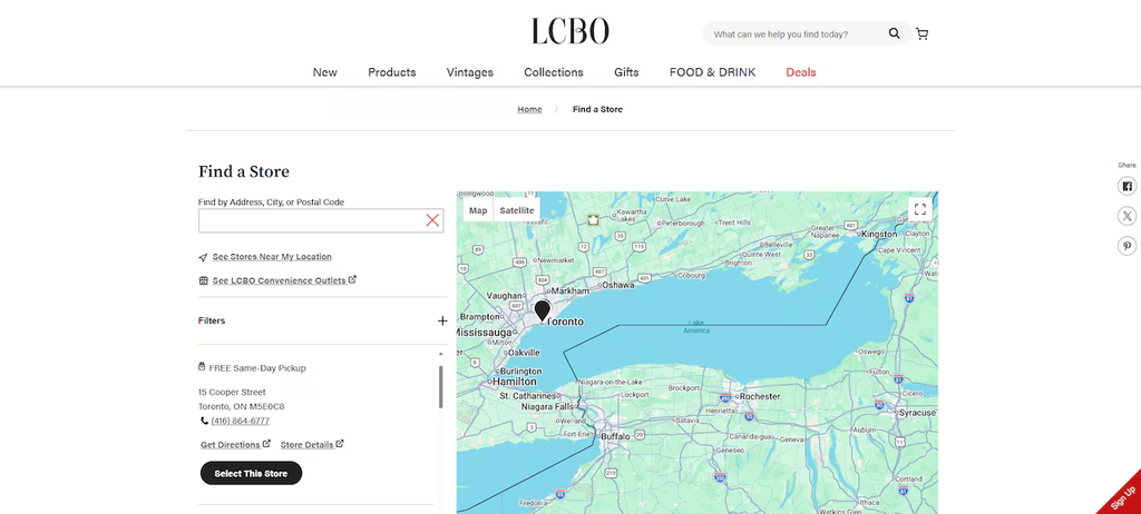
As a result, an individual sitting in Toronto visiting a local government portal or a provincial retail site like the Liquor Control Board of Ontario might see a map labeled Lake America embedded directly on the page.
Ontario Minister Stephen Crawford acknowledged the issue and confirmed that provincial agencies were actively reviewing and updating their website code. Developers across Canada began adding explicit region tags to their Google Maps API scripts to ensure that visitors always see Lake Ontario regardless of server routing.
How Tech Companies and Competitors Responded
The decision to change map labels generated varying responses across the technology sector. While Google implemented the change swiftly to stay in compliance with GNIS guidelines, other mapping providers took different paths.
Apple initially kept the original name on Apple Maps before eventually updating its platform to match federal geographic database records for U.S. devices. This approach reflects how tech giants balance federal regulations with international user experiences, a topic frequently covered across our Technology & AI news section. Similar technical and industry shifts can be seen in hardware markets, such as Apple moving forward with foldable iPhone development and ongoing market debates surrounding investor concerns over AI data center expansion.
In contrast, MapQuest chose a completely different approach. The long-standing navigation service publicly announced that it would not change the name of Lake Ontario on its platform. MapQuest posted statements online making it clear that they intended to keep the original name intact for all users.
To highlight their stance, MapQuest released an interactive tool allowing users to label the lake whatever they preferred. This public stance created massive interest on social media, driving MapQuest to the number one spot on the Apple App Store download charts within days. Millions of users downloaded the application as a gesture of support for keeping traditional place names.
Public and Political Reactions Across the Border
The map update created significant public discussion on both sides of the border. Across Canada, public officials and citizens expressed clear pride in maintaining historical geographic names.
In Ontario, Premier Doug Ford took a visible stance by erecting a large, twenty-four by twelve foot sign near the shoreline in Winona, Ontario. The sign reads Lake Ontario: Now and Always in both English and French. Premier Ford stated in public interviews that regardless of official decisions made in Washington, the body of water would remain Lake Ontario to Canadians and the international community.
Reactions within the United States were also mixed. Several state leaders and federal lawmakers expressed disapproval regarding the order. Democratic Representative Debbie Dingell of Michigan introduced legislation called the Hands Off Our Great Lakes Act, which aims to protect traditional names of shared water bodies and reverse unilateral renaming efforts.
Local officials in states bordering Canada also voiced concerns. New York Governor Kathy Hochul publicly noted that state agencies in New York would continue using the name Lake Ontario on state publications and official documents. Vermont Governor Phil Scott described the decision as an unnecessary distraction during delicate economic negotiations.
These border developments carry important implications for international relations, regional business partnerships, and joint economic projects like those discussed at the Canada Investment Summit 2026.
The Broader Impact of Digital Map Personalization
The Lake Ontario situation highlights an important reality about modern digital infrastructure. Maps are no longer static printed paper sheets hanging on classroom walls. They are dynamic software interfaces that adapt based on software settings, device locations, and regional laws.
Digital map personalization allows technology platforms to comply with local laws in different countries around the world. For example, borders and landmark names often look different depending on whether you access a mapping app from India, China, or Western Europe. Mapping platforms use geographic IP tracking and regional software settings to present localized versions of world geography.
However, this dynamic system also creates new challenges for developers, business owners, and content managers. When map labels change automatically based on backend database updates, organizations must actively manage their web platforms to maintain consistency.
Build Funnels, Email Lists & Sell Online With One Free Tool
Create funnels, send emails, and sell online using Systeme.io without paying for multiple tools.
Create Free AccountFree forever • No credit card • Beginner-friendly
For digital creators and online entrepreneurs, understanding how digital platforms process location data and handle automated updates is essential. Many online creators and media businesses explore automated content systems to reach global audiences effectively. If you want to learn more about automated media and video strategies, explore our full guide on YouTube Automation strategies and workflows.
How Web Developers Can Fix Region Display Errors
For website owners, provincial agencies, and business managers who notice incorrect map labels appearing on their embedded Google Maps, fixing the issue requires updating the API implementation code.
When loading the Google Maps JavaScript API, developers should ensure that the region parameter is explicitly specified in the script tag. Adding region=CA forces the API to deliver localized map tiles that match Canadian geographic standards.
Here is an overview of the key steps needed to resolve map display inconsistencies:
- Review all embedded map scripts across your website or web application.
- Locate the Google Maps API URL tag in your HTML or template files.
- Append the region parameter directly to the script URL using the appropriate two-letter ISO country code.
- Clear website caching and browser cache to ensure that updated map tiles load correctly.
- Verify that mobile and desktop views load the intended regional map labels.
By taking these steps, organization leaders and web developers can ensure that their website visitors see accurate and culturally appropriate map labels regardless of default server settings.
Frequently Asked Questions
Why did Google Maps rename Lake Ontario to Lake America?
Google Maps updated the display name for users in the United States to match official federal records updated by the U.S. Geographic Names Information System following a presidential executive order.
Is Lake Ontario officially renamed in Canada?
No, Lake Ontario has not been renamed in Canada. The Canadian government, provincial leaders, and official mapping bodies do not recognize the change and continue to use Lake Ontario exclusively.
Why do some Canadian websites show Lake America on their maps?
Some Canadian websites show Lake America because their embedded Google Maps software was configured without an explicit region parameter. When no region code is set, the system can default to general North American or U.S. API server settings.
Do other mapping services show Lake America?
Apple Maps updated its display for U.S. users to reflect official federal database records. However, MapQuest declined to change the name, retaining Lake Ontario for all users worldwide.
How can website owners fix incorrect map labels on embedded maps?
Website owners can fix map labels by adding a region parameter to their Google Maps API script tag, specifying the intended country code so that localized map data loads reliably.
Digital Boundaries in an Interconnected World
The debate over the name of Lake Ontario reveals how closely technology, geography, and international relations are intertwined. As digital platforms become the primary way people navigate physical space, map software plays a powerful role in how boundaries and landmarks are perceived. While physical geographical features remain unchanged, digital labels can shift with a single database update.
Understanding how location settings and software APIs work helps individuals and business owners better navigate these digital shifts. Maintaining control over digital presentations ensures clear communication across borders and platforms.
If you have questions, feedback, or news tips about technology updates and trending stories, feel free to visit our Contact Us page or learn more about our publication on our About Us page.
You can also stay connected with us on social media for real-time updates and discussions:
- Follow our official updates on Instagram.
- Connect with our community on Facebook.
- Join the conversation on X (formerly Twitter).
