
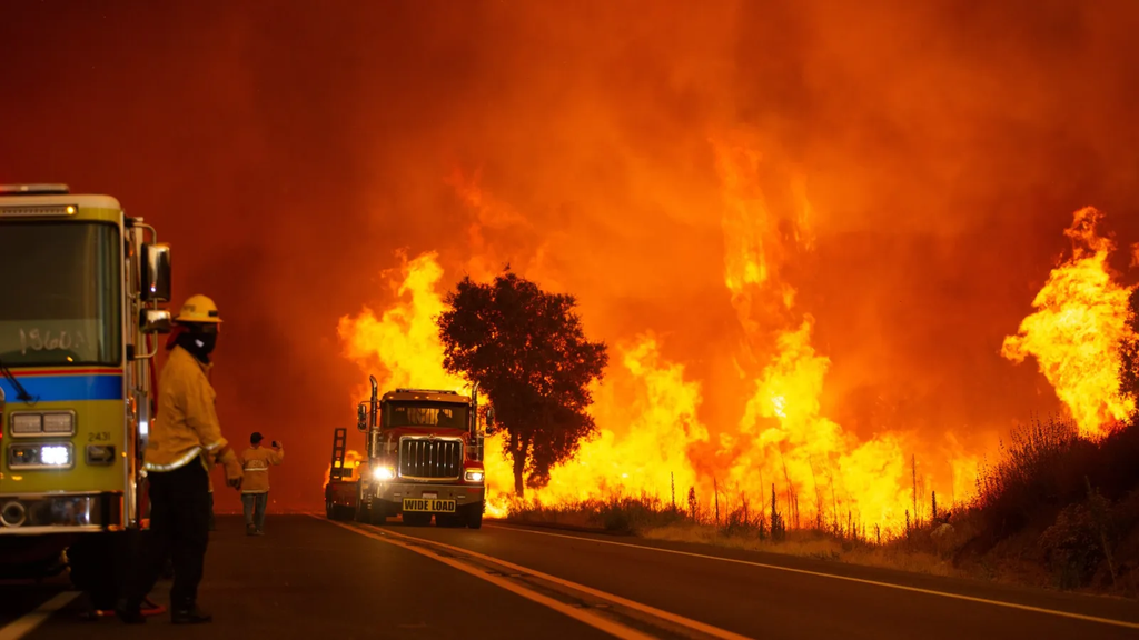
Firefighters along California’s iconic Big Sur coast are fighting one of the toughest wildfire battles of the year. The Timber Fire has expanded dramatically across Monterey County, burning nearly 25,000 acres of steep woodland, brush, and forest. Fire crews have managed to reach 21 percent containment, but dry winds and hot weather continue to push the flames deeper into rugged mountain terrain.
The fast-moving blaze has forced major road closures along Highway 1, triggered urgent evacuation orders for local communities, and threatened over 600 homes and businesses. Popular tourist destinations, historic landmarks, and famous state parks across Big Sur have been forced to close down as emergency teams work around the clock.
This comprehensive breakdown covers everything happening on the ground right now. You will learn how the fire started, where the threat is moving, how emergency crews are working to save homes, and what local residents and travelers need to know to stay safe.
How the Timber Fire Started and Rapidly Expanded
The Timber Fire first broke out on the evening of August 8, 2026, southeast of Loma Vista in the Los Padres National Forest. When the fire began, it was relatively small, but the surrounding conditions created a recipe for explosive growth. The region had suffered through weeks of dry conditions, high temperatures, and low humidity. The trees, shrubs, and dry grass in the wilderness were dry like tinder.
Within just a few days, strong coastal winds pushed the fire across deep canyons and thick forests. Firefighters faced immediate struggles because the land in Big Sur is extremely steep and rocky. Standard fire trucks could not reach the flames in many remote areas, forcing ground crews to hike for miles carrying heavy equipment on foot.
The $0 Secret To Launching Your Entire Online Empire
Why pay hundreds every month for separate software? Build funnels, send emails, and make sales with Systeme.io completely free.
Get Started For $0Free Forever • No Credit Card Needed • Beginner-Friendly
By mid-August, the fire had consumed thousands of acres. Over the following weeks, extreme fire weather kept the blaze spreading north toward the Carmel River drainage and east into the remote Ventana Wilderness. Low moisture levels overnight prevented the ground from cooling down, allowing the fire to keep burning strongly even through the night.
Current Status: Acreage, Containment, and Burned Areas
According to official updates from CAL FIRE incident tracking, the Timber Fire has scorched approximately 24,839 acres in Monterey County. Fire crews have established containment lines around 21 percent of the perimeter, but major active edges remain uncontrolled.
The wildfire is actively moving through several key geographical zones:
- The Ventana Wilderness: Dense brush and dead timber fuel continuous burning deep in roadless territory.
- Lion Creek and Big Sur River Drainages: Steep mountain valleys funnel hot air and carry flying embers into fresh vegetation.
- The Highway 1 Corridor near Pfeiffer Big Sur State Park: Fire has pushed downhill toward coastal access routes, requiring immediate defensive action.
- Coast Ridge Road and Big Pine Ridge: Crews are building emergency defense lines along these high ridges to protect structures.
More than 660 structures remain directly threatened by the flames. Firefighters are prioritizing property protection while attempting to surround active edges before high winds push the fire closer to populated pockets.
Inside the Firefighting Strategy: How Crews Are Battling the Blaze
Stopping a massive wildfire in steep, mountainous terrain requires a combination of ground tactics, heavy machinery, and air support. Fire crews are working long shifts under hazardous conditions to slow the momentum of the Timber Fire.
Tactical Backburning Operations
One of the main strategies used by fire teams along Highway 1 and near Pfeiffer Big Sur State Park is controlled backburning. Firefighters intentionally burn small strips of dry vegetation along roads and created containment lines before the main wildfire arrives. By removing this fuel ahead of time, the main fire starves and slows down when it hits the pre-burned strip.
Ground Crews and Dozer Lines
In areas where heavy machinery can safely operate, bulldozer crews build wide dirt trenches called dozer lines. Near Bottchers Gap and the Los Padres Reservoir, crews are connecting existing roads with new dozer lines to construct primary control features. In areas too steep for machines, specialized Hotshot crews and hand teams clear brush manually using axes, shovels, and chainsaws.
Managing Falling Rocks and Debris
The steep cliffs along the Big Sur coastline present another serious hazard: falling rocks. As the fire burns away tree roots and vegetation that hold the soil together, large boulders and loose rocks roll down slopes onto Highway 1. Specialized crews perform rock scaling, which involves manually removing loose rocks from cliffs before they drop onto emergency vehicles passing below.
Evacuations, Closures, and Impacts on the Big Sur Community
The Timber Fire has caused widespread disruptions for residents, local business owners, and tourists. Big Sur is famous around the world for its dramatic ocean views and redwood forests, but the ongoing wildfire has brought daily activity to a standstill.
Road Closures along Highway 1
Highway 1 is the primary transit artery along the Big Sur coast. The California Highway Patrol and Caltrans have placed hard closures along key sections of the highway to keep roads open for fire engines and heavy equipment. The northern closure stands south of the Little Sur River, while southern closures extend down near Salmon Creek. Travelers are strongly advised to avoid driving toward the area.
Impacted State Parks and Famous Landmarks
Several famous state parks and iconic local businesses have been forced to close down or evacuate. The closed state parks include:
- Pfeiffer Big Sur State Park
- Andrew Molera State Park
- Julia Pfeiffer Burns State Park
- Point Sur State Historic Park
Famous local establishments such as Nepenthe Restaurant, the Henry Miller Memorial Library, and the Alila Ventana Big Sur resort have faced mandatory evacuation orders or warnings. For a community that depends heavily on summer tourism, these prolonged closures create major economic hurdles.
Evacuation Orders and Emergency Relief
The Monterey County Sheriff’s Office has issued mandatory evacuation orders across multiple sectors while placing neighboring areas under evacuation warnings. Emergency shelters have been established in nearby towns to provide displaced residents with safe lodging, meals, and emergency support services.
Why Big Sur Firefighting Is Uniquely Challenging
Battling a fire in Big Sur is very different from fighting fires in flat regions. The local geography and coastal climate create severe obstacles that test even the most experienced emergency crews.
Mountainous and Roadless Wilderness
Much of the land inside the Los Padres National Forest and Ventana Wilderness has no paved roads or driving tracks. Firefighters often have to be flown in by helicopter or hike for hours carrying 40-pound packs just to reach the fire line. When heavy smoke or low clouds prevent helicopters from flying, delivering water and supplies to ground crews becomes exceptionally difficult.
Send, Spend & Hold Money Worldwide Without Hidden Fees
Transfer money internationally at the real exchange rate and hold 40+ currencies in one account.
Open a Wise AccountMid-market rate • Fast transfers • 40+ currencies
Harsh Weather Patterns
Late summer weather in Big Sur can be brutal for firefighting. The region has experienced over ten straight days with relative humidity dropping below 30 percent, with overnight recoveries remaining in the upper teens. High daytime temperatures near 80 degrees Fahrenheit, combined with dry winds, keep trees and undergrowth dry day and night.
A History of Coastal Disasters
The community of Big Sur has survived numerous natural disasters over the past decade. The region has endured massive blazes, including the 124,000-acre Dolan Fire in 2020 and the Colorado Fire in 2022, alongside winter landslides that washed out portions of Highway 1. Each new wildfire reopens challenges for residents who have spent years rebuilding their homes and infrastructure.
The Broader Picture: California’s 2026 Fire Season
The Timber Fire has officially become the third-largest wildfire in California so far in 2026. Reports from CBS News updates on the wildfire highlight that it ranks behind only the massive Bug Fire near the Nevada border and the Biscar Fire in Lassen County.
Regional Air Quality Warnings
Smoke plumes from the Timber Fire extend far beyond Big Sur. Winds have drifted smoke northward across the San Francisco Bay Area and inland throughout the Central Coast. Air quality districts have issued health advisories encouraging children, older adults, and people with heart or lung conditions to minimize outdoor activity. Anyone living in affected regions can monitor live smoke movement using the EPA AirNow smoke map.
Persistent Dry Seasons
Wildfire seasons across the Western United States continue to demand long-term preparation. Extended dry periods during spring and summer leave vegetation vulnerable to rapid ignition from electrical storms, equipment sparks, or accidental fires. Emergency officials warn that high fire danger will likely remain until widespread rain arrives late in the fall.
How to Stay Safe and Follow Emergency Updates
Keeping up with accurate emergency information is essential during active wildfire events. Here are practical ways to protect yourself, prepare your household, and track developments.
Practical Wildfire Safety Steps
- Follow Evacuation Orders Immediately: If local officials issue an evacuation order for your zone, leave right away. Do not wait until smoke or flames appear near your home.
- Keep an Emergency Go-Bag Ready: Pack essential documents, prescribed medicines, fresh water, non-perishable snacks, flashlights, and extra batteries in an easy-to-carry bag.
- Protect Indoor Air Quality: Keep windows and doors tightly closed when air quality drops. Run indoor air filters and wear well-fitted N95 masks if you must go outside.
- Clear Flammable Material Around Property: If you live in a fire-prone zone, clean dry leaves from roof gutters, trim low tree branches, and store flammable furniture away from exterior walls.
Using Modern Digital Tools During Emergencies
Modern technology allows communities to stay informed during natural events. You can register for county text notifications, track emergency mapping portals, and check live weather radars. To learn more about how technological innovation and smart tools assist in monitoring environmental trends, explore our Technology and AI category.
In addition, digital content creators play an active role in sharing real-time news and educational video updates with worldwide audiences. You can discover how online publishing platforms operate by checking out our YouTube Automation category.
Stay Connected with Our Social Channels
Staying connected with verified updates helps communities navigate challenging times together. You can join our online community across our official social channels to stay updated on trending stories and news:
- Visit our Instagram page for visual highlights and quick news roundups.
- Follow our Facebook page to discuss current events with other readers.
- Check our X profile for real-time news alerts and fast updates.
If you have questions, feedback, or news tips you would like to share with our editorial team, feel free to visit our Contact Us page or read more about our background on our About WhatsBuzzn page.
The $0 Secret To Launching Your Entire Online Empire
Why pay hundreds every month for separate software? Build funnels, send emails, and make sales with Systeme.io completely free.
Get Started For $0Free Forever • No Credit Card Needed • Beginner-Friendly
Frequently Asked Questions (FAQs)
How big is the Timber Fire right now?
The Timber Fire has burned approximately 24,839 acres in Monterey County, California, making it the third-largest wildfire in the state in 2026.
Is Highway 1 open through Big Sur?
No, major sections of Highway 1 through Big Sur are closed due to active firefighting operations, backburning, and falling rock risks. Hard closures are located south of Little Sur River down past Salmon Creek.
How much of the Timber Fire is contained?
As of the latest official update from Cal Fire, the Timber Fire is 21 percent contained. Fire crews continue building new containment lines in challenging mountain areas.
What caused the Timber Fire?
The official cause of the Timber Fire remains under investigation by fire authorities. The blaze first began on August 8, 2026, southeast of Loma Vista.
Are state parks in Big Sur open to tourists?
No, several major state parks in Big Sur are temporarily closed for safety. Closed locations include Pfeiffer Big Sur State Park, Andrew Molera State Park, Julia Pfeiffer Burns State Park, and Point Sur State Historic Park.
How can I track air quality updates caused by wildfire smoke?
You can monitor real-time air quality and smoke levels by using the official EPA AirNow Fire and Smoke map online or by following advisories from your local air quality management district.
The Timber Fire remains an active emergency, but the dedicated efforts of over a thousand firefighters, air crews, and support personnel continue to make progress. As emergency teams build containment lines and defend homes, local residents and visitors should follow official instructions, respect road closures, and keep safety first. Staying informed through verified emergency updates is the safest way to navigate through active fire events.
